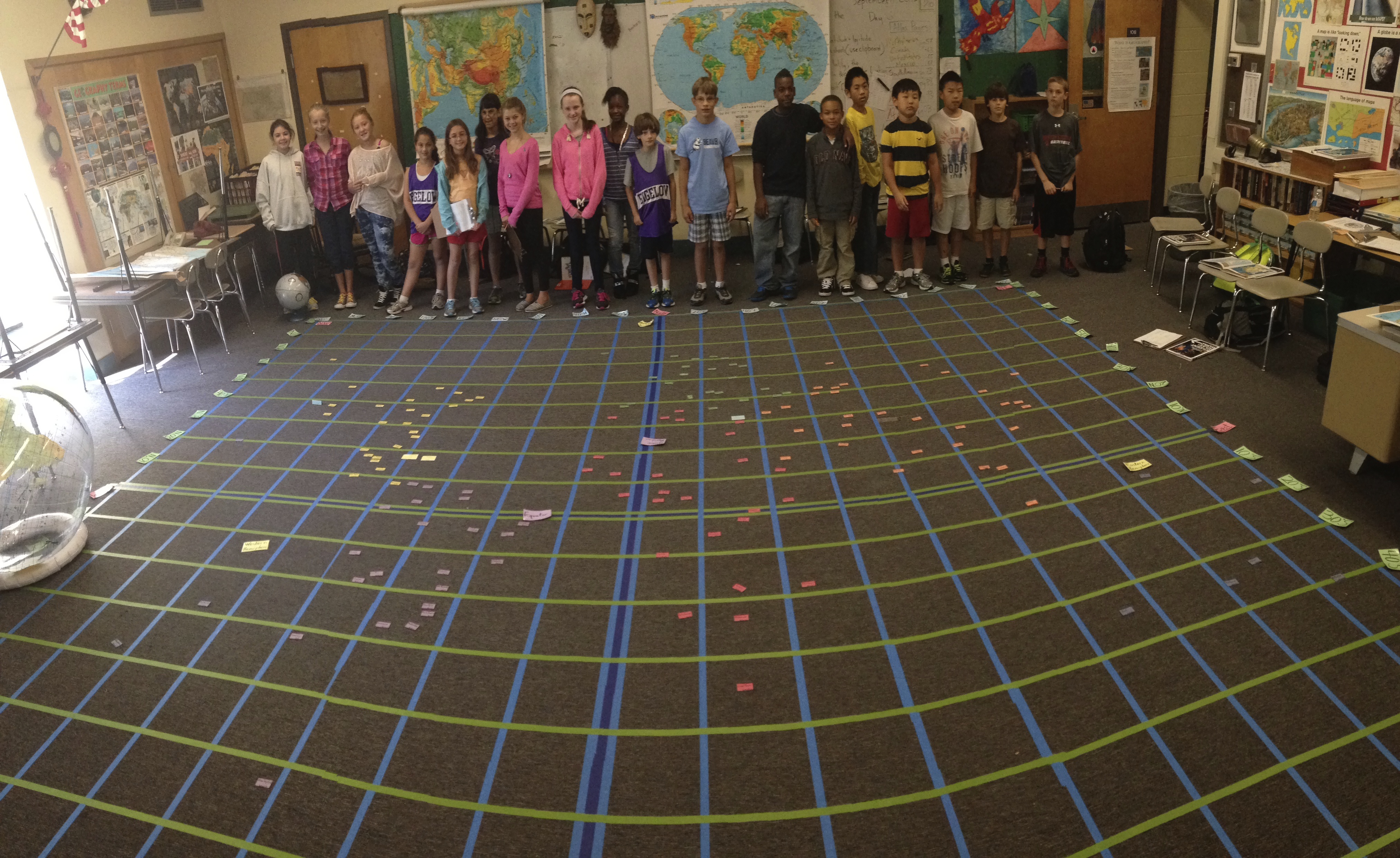
I was recently approached to describe with more detail the process that I use for a Grid activity (If you want to read more about building the Grid, check it out here, and here) that uses data points for cities so students can construct a map of the world. This post will be fairly Spartan but will have all the ingredients needed to build out the picture below.
Materials for Mapping activity
- 1-2 boxes of magnetic business cards $19.00 each
- 6 different colors of construction paper, enough paper for the number of cards for each region.
- scissors
- thin black sharpie
- a class set of atlases (or Google Earth)
You can order the magnetic business cards from any retailer, I went to Staples (the Mecca of any respectable teacher).
I cut the magnetic business cards into thirds and adhere them to sheets of colored construction paper. I don’t pre cut the construction paper here because it’s easier to just cut out the business cards after they have been stuck to the construction paper. The first year I did this I tried to use twenty data points (cities) for each continent. This seemed to work out well but I realized that Asia needed more. I used cities that were on the coast and capital cities for my list but also included populous cities and other data points that I thought could help fill in the map. In hindsight, I should have included more cities from Russia, Siberia specifically, to fill in black space. There are A LOT of data points. You don’t have to use them all (I’m a bit obsessive) To be honest it took me only about 2-3 hrs of time to write out all the names on the magnetic cards in a thin, black Sharpie. The list looks daunting but don’t feel like you have to use every one. Make something that works for you and the outcome that you are trying to get your students to achieve.
List of cities (216 total data points)
North America (28 data points)
Montreal
Boston
New York City
Washington D.C.
Atlanta
Miami
Tampa
New Orleans
Houston
Chicago
St. Louis
Denver
Seattle
Los Angeles
San Francisco
Anchorage
Mexico City
Cancun
Cabo San Lucas
Vancouver, B.C.
Calgary
Belmopan
Guatemala City
San Salvador
Tegucigalpa
Managua
San Jose (Costa Rica)
Panama City (Panama)
South America (23 data points)
Bogota
Caracas
Georgetown
Paramaribo
Cayenne
Quito
Lima
Santiago
Punta Arenas and/or Tierra del Fuego
Stanley (Falkland Islands)
Buenos Aries
Montevideo
Asuncion
La Paz
Brasilia
Sao Paulo
Rio de Janeiro
Salvador
Natal
Fortaleza
Sao Luis
Belem (Mouth of the Amazon)
Manaus
Africa (51 data points)
Rabat
Algiers
Tunis
Tripoli
Cairo
Khartoum
Asmara
Djibouti
Addis Ababa
Mogadishu
Nairobi
Juba
Kampala
Kigali
Bujumbura
Dodoma
Island of Zanzibar
Lilongwe
Lusaka
Harare
Maputo
Mbabane
Cape Town
Maseru
Pretoria
Gaborone
Windhoek
Luanda
Kinshasa/Brazzaville
Libreville
Bangui
Yaounde
Malabo
N’Djamena
Abuja
Lagos
Porto Novo
Lome
Accra
Niamey
Ouagadougou
Bamako
Yamoussoukro
Monrovia
Freetown
Conakry
Bissau
Banjul
Dakar
Nouakchott
Antananarivo
Europe (30 data points)
Lisbon
Madrid
Paris
London
Berlin
Dublin
Rome
Athens
Prague
Warsaw
Copenhagen
Oslo
Stockholm
Helsinki
Amsterdam
Vienna
Budapest
Belgrade
Sofia
Bucharest
Kiev/Kyiv
Minsk
Moscow
Vilnius
Riga
Tallinn
Zagreb
Sarajevo
Tirana
Istanbul
Asia (65 data points)
Ankara
Beirut
Damascus
Jerusalem
Amman
Riyadh
Mecca
Sana’a
Muscat
Dubai
Kuwait City
Baghdad
Tehran
Baku
Tbilisi
Yerevan
Ashgabat
Tashkent
Bishkek
Dushanbe
Kabul
Islamabad
Karachi
Kathmandu
New Delhi
Mumbai
Madurai
Colombo
Hyderbad
Kolkata
Dhaka
Thimphu
Naypyitaw
Bangkok
Kuala Lumpur
Singapore
Jakarta
Bandar Seri Begawan
Phnom Penh
Vientiane
Hanoi
Hong Kong
Zhanjiang
Wuhan
Shanghai
Nanjing
Xi’an
Lhasa
Chengdu
Beijing
Qingdao
Changchun
Shenyang
Ulaanbaatar
Pyongyang
Seoul
Tokyo
Astana
Nagasaki
Vladivostok
Yekaterinburg
Kurgan
Krasnoyarsk
Omsk
Irkutsk
Australia/Oceania (19 data points)
Honolulu
Canberra
Melbourne
Sydney
Perth
Hobart
Wellington
Noumea
Port Moresby
Honiari
Hagatna
Bairiki
Yaren
Suva
Pape’ete
Avarua District
Pago Pago
Adamstown (Pitcairn Island)
Easter Island
Once the map is finished (or close to it), I would take a photo of the class so they could see the results of their work. The finished map is quite impressive and it’s a great jumping off point for any number of conversations about world geography. Why are there so many capitals in Africa? Why did you put so many Chinese cities on the map? How come there are no cities in the northern part of Africa?
I’ve had dreams of getting students to overlay physical features on top of the map but have yet to try it out…I have my limits of insanity.


This was exactly what I wanted to see! I so appreciate you taking the time to reproduce the list as well as your thoughtful insight in the use for learning. A heartfelt thank you!
LikeLike